|
Home
Avionique
Informatique
Mécanique
Librairie
DVD
COMMANDE
NEWS
CONTACT
Liens
Paramoteur
| |

|
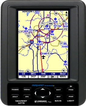
The Lowrance AirMap® 2000C adds to the AirMap®
benefits of excellence in performance and value with an all-new, brilliant,
sunlight-viewable, 256-color TFT display. Features Jeppesen® and Lowrance
Obstructions databases loaded on one 32MB digital memory (MMC/SD) card,
MapCreate™ mapping software, an MMC/SD card reader/writer, a cigarette plug
power adapter along with 4 AA batteries, an advanced remote amplifying
antenna, a yoke-mount bracket, and a suction-cup car mount bracket.
Display <<
 Sharp 5" diagonal (12.7 cm) 256-color, sunlight-viewable TFT display
320Vx240H pixel resolution
Adjustable cold cathode screen
backlighting for night-time viewing
High-speed screen updates
Mapping
<<
Jeppesen® Americas database with Intersections, NDBs, VOR, Airspaces (Class
D included), and all Airport Approach Control and FSS frequencies
Exclusive Lowrance Obstructions database with ground obstructions display in
AGL or MSL heights
Built-in, custom continental U.S. and Hawaii background Moving Map® with
major highways, interstate exit services, and enhanced coastal/inland waters
detail
Accepts custom, high-detail MapCreate™ mapping on MMC or SD memory cards up
to 256MB with searchable POI database of hotels, restaurants, shopping,
services, and more
Navigation <<
12-parallel
channel
GPS+WAAS
receiver with fast satellite acquisition and precise tracking - Comes with
built-in antenna and an advanced RAA-4 Remote Amplifying Antenna
Satellite status, battery life, and digital data position display pages
Position information; lat/lon, altitude and velocity
Quick-access Nearest Airport/Airfield feature
Aviation-only, Aviation+Land, or Land-only Moving Map® display modes
E6B and VNAV computer modes
Customizable display with 20 different navigational information selections
1,000
waypoints/1,000
event markers/100
routes (up to 100 waypoints per route)
Up to 100 savable and retraceable plot trails, with up to 10,000 points in
any trail
42 graphic icons to mark locations
39 map
zoom ranges, 0.02-4,000 miles
Selective on/off visual and audible alarms
Built-in back-up memory keeps stored settings and GPS data safe and
accessible for years
Other
<<
Waterproof to IPX7 standards
External power and serial port connections, plus remote antenna jack
Voltage input from 5 vDC (four AA batteries included) to 35 vDC (via the
cigarette adapter included)
Full one-year warranty; extended warranties available |

|
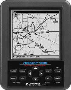
The AirMap® 1000 adds to the AirMap®
benefits of reliability, versatility, and value with an all new 5"
high-contrast screen. Features Jeppesen® and Lowrance Obstructions databases
loaded on one 32MB MMC card, MapCreate™ software, an MMC/SD card
reader-writer, a cigarette plug power adapter, an advanced active remote
antenna, a yoke-mount bracket, a suction-cup car mount bracket, and a wrist
strap.
Display <<
Sizeable 5" diagonal (12.7 cm) high-contrast
Film SuperTwist display
320x320 (h x w) pixel resolution
Adjustable white LED screen
backlighting for excellent night-time viewing
High-speed screen updates
16-level grayscale
Mapping
<<
Jeppesen® Americas database with Intersections, NDBs, VOR, Airspaces (class
D included), and all Airport Approach Control and FSS frequencies
Exclusive Lowrance Obstructions database with ground obstructions display in
AGL or MSL heights
Built-in, custom continental U.S. and Hawaii background map with major
highways, interstate exit services, and enhanced coastal/inland waters
detail
Accepts custom, high-detail MapCreate™ mapping on MMC or SD memory cards up
to 256MB with searchable POI database of hotels, restaurants, shopping,
services, and more
Navigation <<
12-parallel
channel
GPS+WAAS
receiver with fast satellite acquisition and precise tracking
Satellite status, battery life, and digital data position display pages
Position information; lat/lon, altitude and velocity
Quick-access Nearest airport/airfield feature
Aviation-only, Aviation+Land, or Land-only Moving Map® display modes
E6B and VNAV computer modes
Customizable display with 20 different navigational information selections
Selectable WAAS on/off
1,000
waypoints/1,000
event markers/100
routes (up to 100 waypoints per route)
Up to 100 savable and retraceable plot trails, with up to 10,000 points in
any trail
42 graphic icons to mark locations
39 map
zoom ranges, 0.02-4,000 miles
Selective alarms on/off
Built-in back-up memory keeps stored settings and GPS data safe and
accessible for years
Other
<<
Waterproof to IPX7 standards
External power and serial port connections, plus remote antenna jack
Voltage input from 5 vDC (four AA batteries) to 35 vDC (via the cigarette
adapter)
Full one-year warranty
|
|